04 Nov HOUSEFLIES
HOUSEFLIES - Atmosphere and clouds seen by a cluster of wireless sensors
HOUSEFLIES is an innovative, multi-point atmospheric observation system developed under the Philofluid Research Group at Politecnico di Torino (DISAT/DET). It is based on coordinated clusters of newly engineered mini radiosondes—partially biodegradable and designed to perform endoscopic measurements of fluctuating physical and chemical parameters. These lightweight instruments are capable of monitoring conditions both inside natural atmospheric clouds and within anthropogenic environmental clouds, such as those generated by urban centers, industrial complexes, or sudden emergency events (e.g., fires, explosions, hazardous material releases, volcanic eruptions). See Fig. 1 for a conceptual overview.
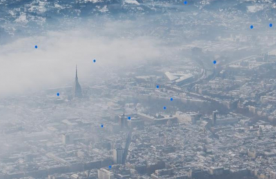
Figure 1. Graphical scheme of the launch of a HOUSEFLIES cluster of radiosondes (in blue) over an urban site, deployed for environmental monitoring purposes.
The primary applications are two-fold:
(I) Introducing a novel method of observation and scientific instrumentation for atmospheric physics, particularly within the terrestrial boundary layer and associated cloud formations
(II) Enabling near-ground environmental monitoring around various sites, including urban areas, narrow and poorly ventilated valleys, infrastructure, and agricultural or industrial facilities that may emit pollutants affecting environmental health.
The first application is in itself very important and completely original in the state of the art, an aspect that has already been recognized internationally by institutions such as the Meteorological Office and the National Center for Atmospheric Science in the UK and by multi-disciplinary journals such as Measurement (Elsevier). In addition to fundamental scientific research, this application has a strong impact on climate and weather forecasting because it has the ability to provide the data necessary for the mutual reconciliation of the results offered by both global and continental climate models used in Europe (ECMWF, UKV, GFS, ICON-D2 / EU). In fact, these currently diverge on the intermediate scale, 100-200 km, which it is important to note is precisely typical of catastrophic events (Ischia, November 2022; floods in Emilia-Romagna, May 2023).
This first application is also strategic in paving the way for the second, i.e. the environmental monitoring market. In fact, the adoption of HOUSEFLIES clusters by prestigious scientific institutes will facilitate their adoption by local government institutions (Regions, ARPA, Department of Civil Protection, National Fire Brigade) active in environmental monitoring, local weather forecasting, and disaster relief. Similarly, as required by the European SEVESO III regulation (Directive 2012/18/CE), the adoption of HOUSEFLIES by local public institutions would in turn facilitate the opening of the self-monitoring market by private institutions such as industries, extractive infrastructures, and agricultural and livestock production.
Technological benchmark and state-of-the-art analysis of the proposed application through a descriptive and tabular analysis
Frequency modulated radio transmission of data using bandwidths specific to the individual product (403 +- 0.87 MHz, 865 +- MHz, 1680 Mhz).
Measurement of pressure, temperature, and humidity by means of PTU sensors and their sending to the ground.
Some also provide information on the position of the probe via GNSS (Global Navigation Satellite System), or an estimate of it through other less direct measurement methods.
Vertical flight, without being able to stop at precise altitudes for horizontal exploration.
For radiosondes launched from the ground, transport via large balloons made of materials with a strong environmental impact.
HOUSEFLIES radiosondes provide the features listed above along with specific new features, namely:
1. The use of Cluster of radiosondes: In-field experiments conducted with a cluster of free-floating radiosondes, listed in chronological order., see Table below.
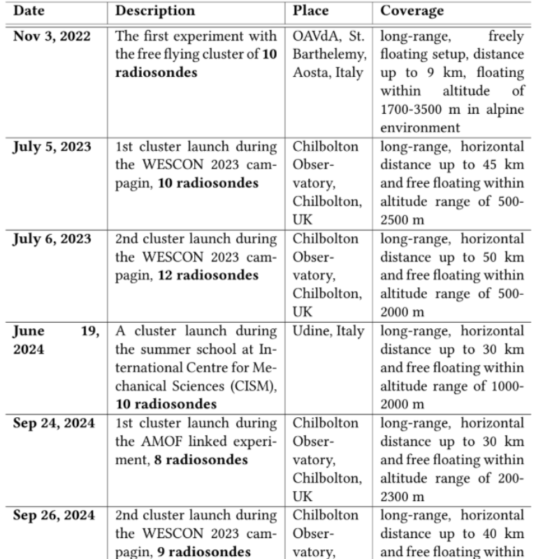
2. Passive Floating (Free Flotation) within the turbulent convective motions of the atmosphere and clouds. This allows prolonged monitoring of the environment horizontally up to 100 km and vertically up to altitudes of about 5 km above the ground, corresponding to the maximum possible thickness of the Earth’s boundary layer. The passivity of transport, as opposed to active flight such as that of drones and aircraft, is important because it allows the monitored environment not to be disturbed. It was achieved due to the reduced mass (less than 20 grams) and volume (helium balloon less than 30 cm in diameter) of our prototype. Due to this, for both European and national (ENAC) regulations, HOUSEFLIES probes, do not require a permit to fly (ENAC regulations).
3. Tracking of small-scale Lagrangian trajectories: tracking of small changes in physical quantities, such as position, velocity, acceleration, humidity, pressure, and temperature useful for understanding cloud microphysics, at the moment not yet fully parameterized.
4. Detection of chemical and particulate pollutants (PM 2.5/10, CO2, CO, VOC), in future perspective downstream of the inclusion of dedicated sensors in the PCB.
5. Green balloons: helium balloons that accomplish passive transportation are biodegradable.
Below, you can see the comparison of the features of HOUSEFLIES with existing solutions on the market for atmospheric measurements Table 1.
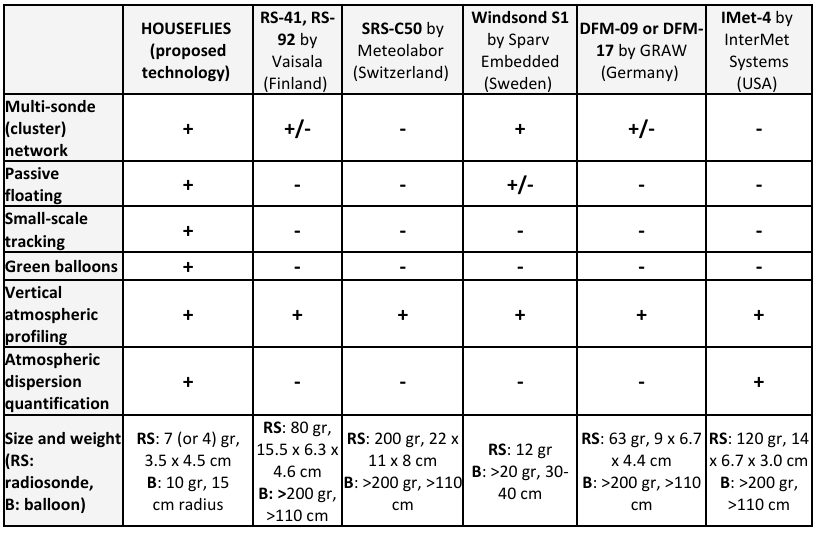
Table 1. Comparison of the features of HOUSEFLIES with existing solutions on the market for atmospheric measurements
Analysis and description of project requirements and specifications
The project came about by observing that current field measurement technologies for climate monitoring, e.g., NCAR – US drop radiosondes or atmospheric radiosondes, fail to extract data on the fluctuation of physical quantities needed to understand the internal behavior of clouds. Current radiosondes are unable to monitor them adequately because they are incapable of floating for long within their turbulence without irreparably changing the measurement environment. The project idea was initially introduced within the European H2020 project MSCA ITN ETN COMPLETE, www.complete-h2020network.eu, during which innovative scientific and technological aspects were defined on which to base the proposed improvement of the current method of observing atmospheric clouds.
The first version of the prototype of mini green radiosonde floating passively in the atmosphere was developed both under the COMPLETE project (2017-2021) and later (December 2021-December 2022) under the POC-Instrument project with the title MIGRE – MINI GREEN ULTRALIGHT EXPENDABLE RADIO SONDE. In this, relative to the first prototype, we achieved an intermediate TRL between 5 and 6. Essentially, in MIGRE, based on the laboratory tests and ground experiments, we first verified the good performance of the first prototype and then began the development of a second prototype aimed at optimizing the weight and size of the printed circuit board, see Fig.2 in which you can see the radiosonde assembled in the panel (a). The integrated electronics can measure the fluctuations of 4 vectors (the position of the probe, its velocity and acceleration, and the local magnetic field) and also 3 scalar quantities (pressure, temperature, and humidity in the surrounding environment). Fig. 2 (c) shows both the current prototype (red) and the second smaller, two-layer prototype (in green).

Figure 2. (a) Radiosonde attached to the ground with a wire during a field test. (b) The current version of the radiosonde electronic board with a battery. (c) The current prototype (red) is presented along with a potential smaller two-layer design (green) and a two-euro coin for size comparison.
At the end of the POC-Instrument MIGRE, all the following requirements had been achieved for the first prototype, see Figures 2 and 3:

Figure 3. Illustration of the field experiment with a radiosonde group and a set of receiving stations. The radiosonde cluster floats through the isopycnic layer at the preconfigured target altitude (1-2 km). The starting point of the cluster is considered as the origin of the observation frame of the experiment, XE, YE, ZE.
Lightness: total weight of about 20 grams
Compactness: the size of the probes is 5×5 cm, and the balloon has a diameter of ~30 cm.
Low cost
Low power consumption, with battery power lasting several hours
Balloon with low environmental impact, thanks to the exclusive use of a biodegradable material, NOVAMONT Mater-Bi®
Ability to float along isopycnic surfaces within the atmosphere, Figures 3-4.

Figure 4. Complete experimental setup for the use of HOUSEFLIES radiosondes.
The first requirement and specification of this second design phase, POC-Transition. The second prototype has problems in matching its two antennas, the one for communication with the satellite constellation at frequency L1 (1575.42 MHz), and the one for communication with both fixed and mobile receiving stations on the ground through LORA transmission protocol. Thus, in this POC-Transition project, we aim to continue the development of the second prototype, overcoming the problem present in the transmission part of the circuit, see section 4, WP1.
The structure and performance of the first prototype, which we consider to be very successful, given the excellent international reception of the design idea behind the radiosonde clusters developed in H2020 COMPLETE and MIGRE.
The achievement of TRL level 5-6 was verified by a series of preliminary field experiments, see Figure 5 and Tables 2 and 3, which summarize all the different field experiments carried out in both Italy and England. These tests demonstrated the operation of the probe system, i.e., the measurement of average values and fluctuations of pressure, temperature, humidity, position, velocity, acceleration, magnetic field, and related radio transmission of data packets. During some of the validation tests, specifically those conducted in England, the proposed measurement system was compared and validated against the methods and measurement instrumentation present at the Chilbolton Observatory. This consists of observations by a large weather radar, cloud radar, lidar, and hourly repeated atmospheric surveys (8 am – 4 pm). See Figure 4, which represents the instrumental capabilities possessed by MET OFFICE and NCAS.
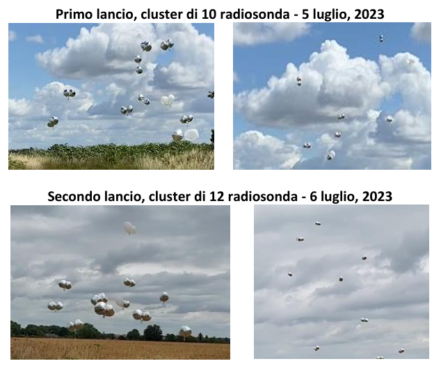
Figure 5. The experimental context for WESCON 2023 included cluster launches of the HOUSEFLIES POLITO radiosonde system. These launches were carried out on intensive observation period (IOP) days, which took place on July 5 and 6, 2023.
At the same time, it should be noted that the results that can be obtained through simultaneous measurements from a cluster of radiosondes such as HOUSEFLIES at present are not feasible to obtain with the instrumentation present both at the Chilbolton Observatory and at other observational sites in Europe and the rest of the world, see Figures 6-9. In fact, HOUSEFLIES allows multipoint endoscopic observation of the atmospheric boundary layer and any cloud formations within it, see Figure 7, over extended spatial volumes and time windows.

Figure 6. Radiosonde trajectories during two flights. Data transmission continued during the experiments for about 1.5 hours until the radiosonde reached a horizontal distance of nearly ~50 km. The dispersed radiosonde cluster remained within the boundary layer during the flight (500 to 2000 meters). We received packets on average every 4-5 seconds from the radiosondes.
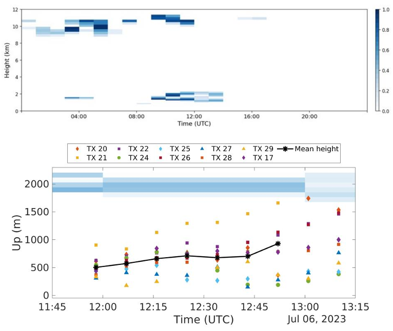
Figure 7. A fluctuating cluster of radiosondes is approaching the boundary layer clouds. The cloud fraction is generated using the ECMWF (European Centre for Medium-term Weather Forecasting) IFS forecast model using the Chilbolton CL51 ceilometer and/or the Chilbolton Copernicus cloud radar dataset.
The data obtained from the trajectories traveled by each radiosonde, see Figure 6, can be effectively integrated and correlated with each other. This integration process leads to the generation of a multi-Lagrangian dataset (defined as a set of data measured along specific trajectories visited by portions of the fluid). The resulting dataset is valuable for conducting diffusion or concentration analyses of turbulent kinetic energy, the latter an important quantity in the study of, for example, thunderstorm events. In addition, using clusters and monitoring multiple physical quantities greatly increases the number of combinations of possible Lagrangian cross-correlations. Table 3 shows the first three in-field experiments performed with our probe clusters, see also Measurement 2024, DOI:10.1016/j.measurement.2023.113879.
The timeline of all in-field experiments can be seen below
20/10/2020 – Drone and INRiM experiment
– Drone experiment
– INRiM probes are used to validate PHT sensors
– Drone trajectory data is used to validate the trajectory of the radioprobe
– Results are used to publish the MPDI sensors paper
– GW from radioprobe, UAV logs from Drone, and INRiM
09/11/2020 – Experiment with Balloon
– First experiment with biodegraable balloon with helium inside
– Radioprobe was fixed inside the balloon pocket
26/11/2020 – Experiment with Phone
– In order to validate the positioning data, we have used this experiment
– Drone experiment was noisy, so we decided to check the positioning in 2D
09/06/2021 – Levaldigi Airport experiment with ARPA Piemonte, 2nd launch
– This experiment was to verify the correct functioning of the positioning sensors
– Moreover, we aim to identify the biases of the PHT sensors
20/07/2021 – Experiment with 2 balloons in INRIM, 1st launch
– 2 radiosondes are tested to check two different configurations
– 1st configuration: radioprobe is inside the balloon
– 2nd configuration: radioprobe is outside the balloon
29/09/2021 – Experiment in INRIM with 5 balloons, 2nd launch
– We tested 5 radiosondes with 2 ground stations
– The first test of multiple radiosondes with a previously selected configuration
– Datasets will be used for relative positioning analysis
10/02/2022 – Experiment in Valle d’Aosta, Osservatorio Saint Barthelemy with 5
tethered ballons
– We tested 5 radiosondes with 2 ground stations
– We used 2 cameras for stereo vision analysis
– Camera dataset will be used to validate positioning sensors
03/11/2022 – Experiment in Valle d’Aosta, Osservatorio Saint Barthelemy with 10
balloons
– We tested 10 radiosondes with 2 ground stations
– Radiosondes are released into the atmosphere
– We used 2 cameras for stereo vision analysis
– Camera dataset will be used to validate positioning sensors
– Reference PHT readings/ calibration from INRIM, Chiara, and Andrea
05-06/07/2023 – Experiment in WESCON 2023 (Chilbolton, UK)
PRELIMINARY: Relative measurements and Lagrangian correlations from a radiosonde cluster dataset. For more details see https://hdl.handle.net/11583/2990509 Preliminary_results_POLITO_WESCON_2023-2 (1)
19/06/2024 Radiosonde cluster launch experiment CISM, Udine, Italy
For more details, see POLITO_RS_CLUSTER_UDINE_experiment_19062024
23-27/09/2024 Radiosonde cluster launch experiments – Chilbolton Observatory, Chilbolton, UK
two more cluster launches between September 23rd and 27th. The first launch, on September 24th, involved 8 radiosondes, though 3 had a short operational lifespan. These radiosondes were transported exclusively by handmade biodegradable balloons made from Mater-Bi. The second launch, on September 26th, comprised 9 radiosondes, each carried by one biodegradable balloon, further supported by a fixed-volume Mylar balloon.
For more details, Radiosonde_cluster_experiment___Chilbolton_2024
Data set describing the collection of all field experiments conducted to date https://hdl.handle.net/11583/2990509
25/05/2025 First Experiment on Radiosonde Using LoRaWAN Protoco by Philofluid Group
On June 25, 2025, the Philofluid Research Group, led by Prof. D. Tordella at Politecnico di Torino, successfully conducted its first experiment utilizing the LoRaWAN protocol (Long Range Wide Area Network) for data transmission collected by a radiosonde. This innovative communication protocol was implemented using a public network, showcasing the potential of LoRaWAN for reliable and efficient data transfer.
This experiment demonstrated the viability of integrating LoRaWAN communication into the radiosonde project, marking a significant step forward from the previous peer-to-peer approach. Despite inherent constraints like duty cycle limits, the LoRaWAN protocol proved effective in transmitting environmental and positional data over long distances. While the average data reception interval was not always ideal, particularly after landing, this was largely attributable to the gateway density in the operating area, a challenge expected to be mitigated in the future by managing launch programming and monitoring atmospheric currents.
The flight provided valuable insights into the radiosonde’s trajectory and environmental profiles, clearly illustrating its transition through the ABL and the thermal inversion zone. The derived velocity and basic spectral analyses, though qualitative due to data resampling, further contribute to a comprehensive understanding of the radiosonde’s performance. Overall, this test represents a solid foundation for future developments of the radioprobe, as the advantages of the LoRaWAN network offer a promising solution for our data telemetry, especially when the key is deploying entire clusters of radiosondes.
16/06/2025 Successful Cluster Experiment in Vipiteno under TEAMx
We are pleased to share a summary of the latest field experiment carried out within the framework of the TEAMx initiative, led by the Philofluid Research Group under the coordination of Prof. Tordella. The experiment took place on 1 July 2025 at the NCAS observation site in Vipiteno/Sterzing, located in the Alpine region of South Tyrol.
This successful experiment was made possible through close collaboration with several partners: NCAS: Andrew Orr and Phil Rosenberg, GRABO: Simone Imola and Margherita Serinelli, and with Philofluid Research Group – Politecnico di Torino: Prof. D. Tordella, Dr. Shahbozbek Abdunabiev, Eleonora Zulli, and Riccardo Villa
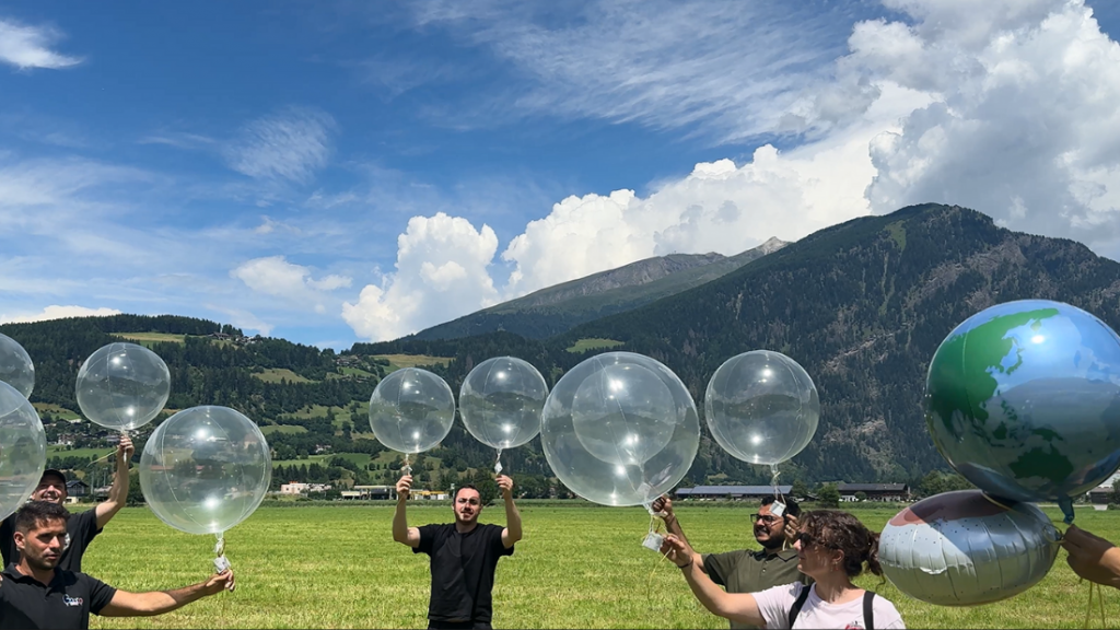
Initial Insights from TEAMx Experiment at Vipiteno/Sterzing
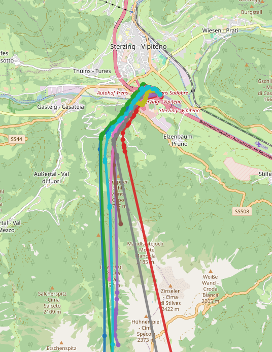
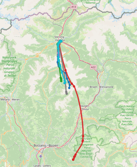
Preliminary results from our recent field campaign conducted under the TEAMx initiative at the NCAS observation site in Vipiteno/Sterzing. The experiment involved the launch and tracking of multiple radiosondes, with the aim of analyzing their vertical and horizontal trajectories, along with associated atmospheric parameters.
Figure 1. Visualizations of the radiosonde flights, illustrating both horizontal and vertical trajectories alongside corresponding atmospheric profiles, including temperature, humidity, and pressure recorded during each flight.
These results are preliminary and were generated by merging datasets from three different sources:
- Public LoRaWAN network
- Local LoRaWAN receiver
- Local peer-to-peer gateways/receivers
For more details on this section, you can see https://iris.polito.it/handle/11583/2990509
Please see the Press review https://philofluid.polito.it/wp content/uploads/2025/01/PRESS.POLITO_13264102.pdf
See updated news Poliflash News


